Sturt Stony Desert Overview
Designation:
Australia-SA_NE-Sturt
Location:
| Latitude | Longitude |
|---|---|
-28.333333° | 138.666667° |
Locality and ownership:
Birdsville track to east of Lake Eyre. Pastoral Leases.
Access:
Along Birdsville track between Maree and Birdsville. This is probably best regarded as a 4WD track. The various homesteads will have air strips.
Local contacts:
Nearest services:
Maree
Risks:
The terrain posses little hazard, except along the edges of the breakaways and of being bogged in the dunes. The remoteness is a hazard, and the area should not be visited without two vehicles and appropriate supplies of water food, and good communications and emergency procedures. The nearest hospital is at Leigh Creek, The risk factors are medium-high, increasing with distance away from the Birdsville track.
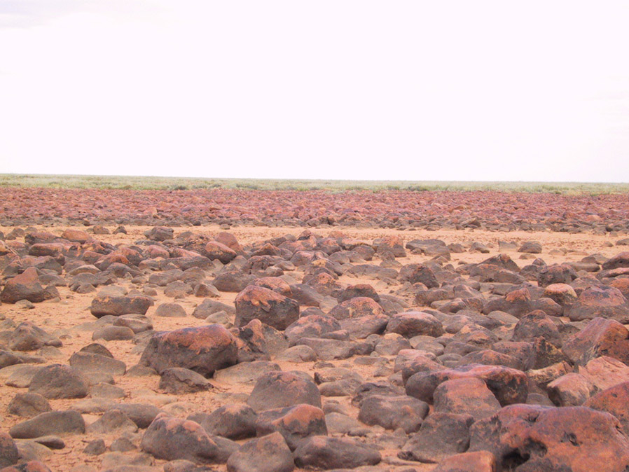
Terrain:
gibber plain
General:
The geology of the area is complex. Gently deformed and duricrusted Cretaceous Bulldog shale of marine origin form the gibber plain uplands of the Stony desert. Eocene and Miocene fluvial and lacustrine sediments have also been weathered and duricrusted, forming breakaways. The area is cut by several major ephemeral streams, including Coopers Creek, and the desert is flanked by the dunefields of the Strezleki desert. There is considerable geological interest in the area because of the record of surface environments in the Eyre basin over the past 40 million years, and the famous silcrete floras and mammalian megafauna. Despite this the area is poorly studied. Almost nothing has been published on the regolith and geomorphological history of the Stony desert itself. Flowing hot artesian wells along the track have deposited locally extensive sinters. The potential for new geological research is high.
Images:
Climate:
Arid, driest part of Australia. Nearest BOM Weather Station: Moomba
Flora and fauna:
The flora and fauna in this arid area is sparse and typical of the region. The potential of the flowing hot artesian wells as an environment for extremophiles is unexplored.
History:
The area was first explored in the 19th century by Strezleki, Sturt, and Eyre. Subsequently there has been sparse use by pastoralists, aided by development of groundwater resources in the Great Artesian Basin. The Birdsville track was originally developed as a stock route and then upgraded as an access road for the Moomba oil and gas fields. The track has becoming increasingly popular as an overland route between Queensland and South Australia for trekkers and 4WD enthusiasts.
Analogue value:
The complex interrelationship of lacustrine, fluvial, and aeolian sediments and variable development of duricrusts offer good scientific analogues for Mars, although the prevalence of carbonate and sulphate soils and sediments may not be. The gibber plains, breakaways, channels, and dunes provide a good terrain for marsupial tests, and some parts, owing to sparse vegetation, are probably among the best for visual analogues. Overall rating very high.
References:
- Alley, N. F. 1998. Cainozoic stratigraphy, palaeoenvironments and geological evolution of the Lake Eyre Basin. Palaeogeography, Palaeoclimatology, Palaeoecology 144: 239-263. The most recent compendium on the environmental evolution of the region.
- Callan, R. F., Dalhunty, J. D., Lange, R. T., Plane, M., Tedford, R. H., Wells, R. T., Williams, D. L. G. 1986. The Lake Eyre Basin - Cainozoic Sediments, fossil vertebrates and plants, silcretes and climatic implications. Australasian Sedimentologists Group Field Guide Series 4. Geological Society of Australia. A very useful compendium of the geology of the lake Eyre basin. The locality guides are however, along the southern part.
- Sampson, L. 1996. The Great Artesian Basin well rehabilitation program 1977095. MESA Journal 3:26-28. Brief description of the uncapped Artesian wells, some very hot, along the Birdsville TrackWilliams, A. F. 1975. Gason 1:250,000 geological explanatory notes. Geological Survey of South Australia.
Map reference:
Geology
Help the MSA!
This week @ NASA