Main menu
You are here
Home ›Arkaringa
Designation:
Australia-SA_Arkaringa_Hills
Location:
| Latitude | Longitude |
|---|---|
-27.903569° | 134.849625° |
Locality and ownership:
Arkaringa Station, SA Pastoral Lease L2418, 2476 (Coorikiana).
Access:
North of Coober Pedy 141km to Mt. Barry. From there travel approximately 50km NW towards Arkaringa Creek and Mt. Arkaringa. Road is somewhat unreliable, especially in wet weather.
Local contacts:
Local property manager Rob ? Sgt. Mark Sutton, Oodnadatta Police Station.
Nearest services:
Oodnadatta
Risks:
Cliffs are high and slippery. There is a risk of access road closure due to flooding. There is a risk of heatstroke and dehydration in summer when temperatures frequently exceed 40 degrees.
Terrain:
stream channels, mesas
General:
Site descriptions:
- Bench at lunch spot was a valley floor strewn with pebbles and coarse sand forming a pavement strongly silicified, and feruginised rock. Below this thin rockly layer soft, red quartz sand forms a shallow layer above harder bedrock.
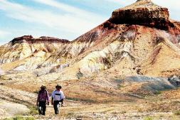
- The eroded edge of 2a is an escarpment (~35 deg) cut into the bedrock of Cretateceous Bulldog shale - a thick mudstone and shale unit. The erosion takes place in steps where the exposed soft bedrock is rapidly undercut. Stongly weathered yellow, orange or white clay stone. Occassional ironstone bands that have hardened on exposure. These shales grade downwards to gray and pale green siltstone. The least weathered shale is observed elsewhere in black and dark grey shale and mudstone. The steep erosional gullies transport fragments of the hard rock from the gravel pavement of 2a combined with debris from the weathered bedrock. As the slope decreases the gravel deposits as fan-shaped lobes and the finer silts and sands are washed downstream.
- The present stream channel consists of muds interbedded with channel sands and gravels. The stream is incised by up to 0.5m and the terraced banks show various sedimentary features including lenses of sand within muds, fine gravel and anti-dune structures (this indicates a very high velocity flow).
- Large pair of mesas formed processes similar to 2b, but on a larger scale. Yellow, orange and white clay stone.
Climate:
Variable. The average annual rainfall is 150mm, but the rain is charcterised by very large peak falls, producing occassional floods. Minimum monthly average temperaturer (July) is 6 deg and the maximum is 35 deg. The temperature can fall below freezing in winter.
Flora and fauna:
Scattered arcacia mulgas of less than 3m follow the creekbeds. Very small Eremophila trees also around the creek beds. Abudant Old-Man saltbush covers many of the slopes. A variety of daisy species scatter amoung the rock. 3-4 grey kangaroos; kangaroo droppings sighted on top of a mesa! Zebra finches. spiny cheeked honey eaters, crested pigeons claimed to be common. Hawktail kite sited.
History:
The area was explored mining companies Comalco and Meekatharra during the 1980s. Sub-bituminous coal was discoverd 100-150m below the surface.
Analogue value:
Entire site was quite bereft vegetation. Distinct levels of erosion and weathering forming plateaus and gullies. There was evidence of slope wash/processes of slope erosion. The biological interest of the site (such as water boreholes) is rated low to moderate. The range of possible engineering operations testing opportunities is moderate. The sizes and distribution of rocks was similar to the Chryse Planatia from Viking photographs in sites 2a and 2b. Visually the site was excellent. The amenties were quite remote and could be practically innaccessable at some times of the year.
References:
- van Oosterzee, P. A 2000. Field Guide to Central Australia. Marleston, SA: J.B. Books.
Map reference:


